
Chapter 2: Regional
Views
 |
 |
|
|
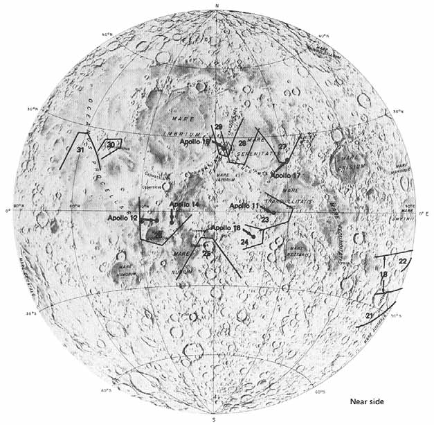
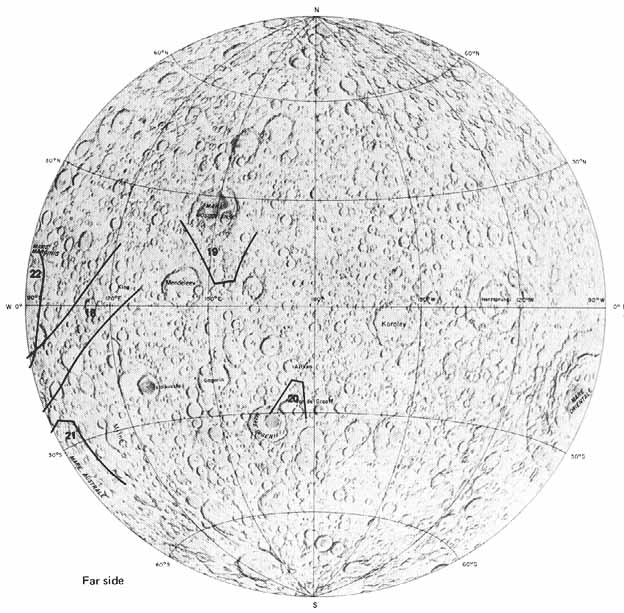
[31] Regional pictures of the sunlit half of the Moon were taken adjacent to the orbital tracks. The pictures in this chapter were selected to show the broader aspects of the lunar surface. Because large features are being shown, many of the pictures in this chapter are oblique views that cover larger areas of the surface. Views taken from the same altitude with the same camera aimed perpendicular to the surface would have been of much smaller areas. Also included are two distant views taken after the Apollo 17 spacecraft had begun its return to Earth.
The terrae dominate the lunar surface, occupying more than about 85 percent of the entire Moon (Stuart-Alexander and Howard, 1970). They are visible from Earth as the brighter parts of the Moon. Viewed through telescopes, they are seen to be more rugged, more densely cratered, and higher in elevation than the mare areas. Terrae have long been proposed to be older than the mare areas on stratigraphic grounds, and now recent studies of samples returned by the astronauts have confirmed this age relationship. Most terra rocks dated by radiometric methods are 3.95 billion years or more in age.
In contrast, the mare areas, including the large irregular area known as Oceanus Procellarum, occupy only about 15 percent of the Moon's surface. They are the dark areas visible from Earth with the unaided eye. In addition to being darker, maria are much less densely cratered and hence smoother than the terrae; most mare areas are relatively level and many occupy depressed areas. These aspects have all suggested that they consist of basaltic lava flows. Such flows occupy extensive areas on Earth, both under the ocean floors and on the continents. Some of the returned lunar samples do consist of basalts that are in many respects similar in chemistry and mineralogy to terrestrial basalts. Radiometric age determinations have shown that most of the basalts sampled to date cooled between 3.2 and 3.8 billion years ago.
Debate about the origin of the mare basalts continues. Perhaps further study of the returned samples, of geophysical data gathered in situ on the lunar surface, and of geophysical and geochemical data obtained from orbit will settle the problem of why the basalts formed and accumulated where they did.-H.M.
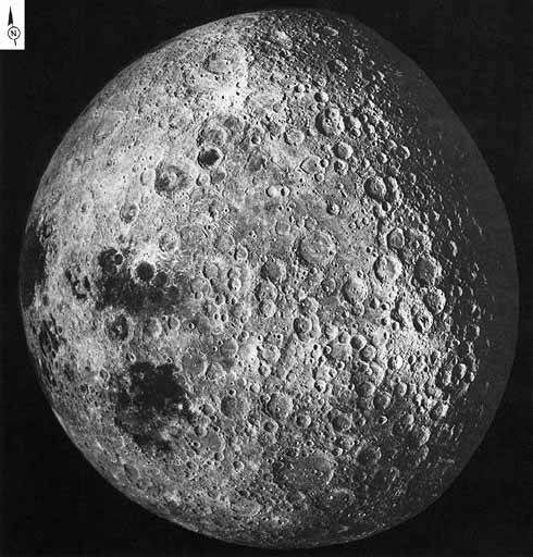 |
[32-33] FIGURE 17 [left] .-A part of the Moon never seen by man until the space age. The far side was first photographed by the U.S.S.R. spacecraft Luna 3 and later directly viewed by American astronauts from Apollo spacecraft. Taken by the Apollo 16 mapping camera on the flight back to Earth, this view is centered at about the easternmost part of the Moon visible from Earth. The dark smooth area at the left edge of this picture, Mare Crisium, is a conspicuous feature near the right side, or eastern limb, of the Moon, as seen in the evening sky. The other two large maria, Mare Marginis to the right of Crisium and Mare Smythii below it, are seen either not at all or are greatly foreshortened. The right half of this picture, which is nearly devoid of maria, was totally unfamiliar to Earth-bound observers. It is typical of the highly cratered, ancient terrae or uplands that occupy nearly 85 percent of the Moon's surface. Some early astronomers, however, correctly predicted that the Moon's far side would have far fewer maria than the near side and that it would be dominated by craters. The rocks that underlie the maria are now known to consist of basaltic lava, a type of rock distinctly different from the bedrock of the densely cratered highland areas of the Moon. Why there are so few maria on the far side is one of the many puzzles still under discussion.-D.E.W. |
AS17-3153 (P)
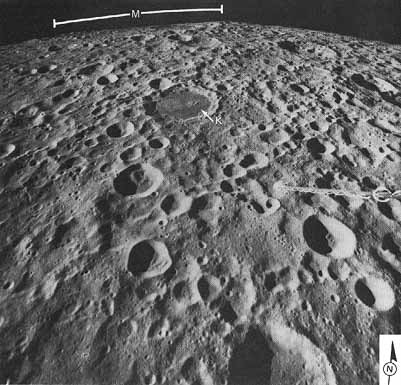 |
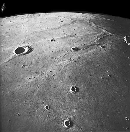
[34] FIGURE 19 [left] . An oblique view of an area near the center of the far side taken with the Apollo 16 mapping camera from orbit at an altitude of 166 km. Like most of the far side, this lunar highland area is pockmarked with numerous craters tens of kilometers in diameter superposed on older terrain. The dark-floored crater (K) in the upper center is Kohlschütter. It is about 60 km in diameter and is filled with basaltlike mare material. This makes it one of the few craters on the lunar far side smaller than 100 km in diameter that contains mare material. The sharp rise near the center of the horizon is the southeastern rim of Mare Moscoviense (M). The caduceuslike object protruding into the view from the right edge of the photograph is the boom of the gamma ray spectrometer. A detector at the end of the boom measured the concentration of radioactive materials on the lunar surface along the ground track of the spacecraft. F.E.-B.
|
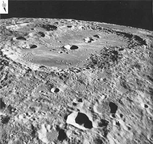 |
FIGURE 20 [left] .-The very large "twin crater" in this southward-looking oblique view is Van de Graaff, approximately 250 km in length. The dark oval area in the upper right corner near the horizon is the mare-filled crater Thomson, which in turn lies within a much larger mare- filled circular basin that contains Mare Ingenii. The crater Van de Graaff itself is filled with both light plains and mare materials. The darker patch at the near end is mare material, and the hummocky material along its left (east) side is ejecta from the crater Birkeland (B). Light plains materials are also visible in the near field within smaller craters and in areas between them. This region of the lunar far side is of particular interest for two reasons: (1) it has the highest concentration of natural radiation yet recorded on the lunar far side by the gamma ray spectrometer (Metzger et al., 1973), and (2) it is also the site of the most prominent magnetic anomaly associated with the far-side highlands (Coleman et al., 1972a).-F.E.-B. |
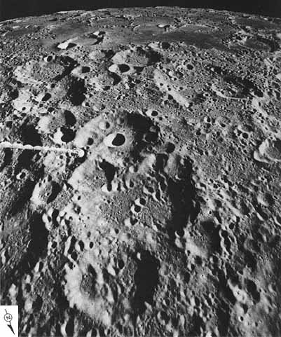 |
[35] FIGURE 21 [left] .-This view, one of the most southerly photographed by the Apollo astronauts, straddles the boundary between near and far sides and shows terrain typical of both sides. In the foreground is densely cratered terra or highland terrain typical of the far side. At the top of the picture a large area is covered by mare material, which is easily distinguished from the terrae by its smooth appearance and darker color. This mare area, appropriately named Mare Australe (Southern Sea), occupies a large old circular basin-probably a gigantic impact scar. The rings and arcuate segments of rings projecting through the mare are the rim crests of smaller craters that were created after the basin was formed but before it was filled. On the far side otherwise similar old basins have less mare filling or none, whereas most circular basins on the near side are deeply flooded by mare material. D.E.W. |
AS17-2871 (P)
|
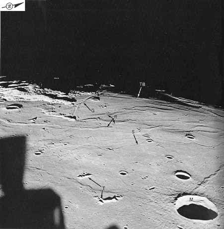
[36] FIGURE 23 [right] .-This view is entirely on the near side where the monotony of the terrae is interrupted by broad expanses of maria. The first two Apollo landing missions were on the relatively smooth maria in areas that were unobstructed by mountains along the approach route. Here, looking westward from the window of the Apollo 11 CM Columbia during its approach, is a view of southwestern Mare Tranquillitatis. Tranquility Base (TB), where Neil Armstrong and Edwin ("Buzz") Aldrin aboard Eagle made the first lunar landing, is barely visible along the terminator beneath the arrow. The maria are invariably described as "smooth." In a relative sense this is true, but only when they are compared with the much more rugged terrae, such as those south (to the left) of the landing site. Here, as in most mare areas, the "smoothness" of the mare surface is interrupted by craters, numerous mare ridges (as at R), straight rilles or grabens (G), sinuous rilles (S), and islands of unburied terrae (T). Some craters like Maskelyne (M) have extensive aprons of ejected debris that further contribute to the roughness of mare surfaces. The dark area in the lower left is not a huge shadow on the lunar surface but is one of the LM thrusters. (It is so close to the camera that it is out of focus.) For an idea of the scale of this picture, the distance from the center of Maskelyne to the landing site is 210 km.-D.E.W.
|
 |
|
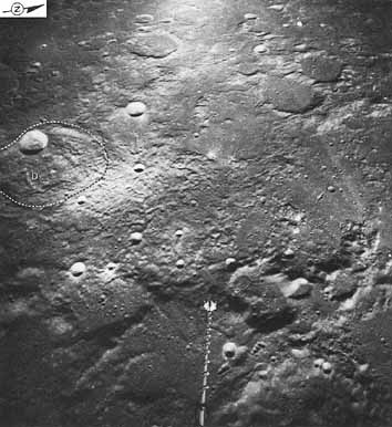
[37] FIGURE 24 [right] .-Looking westward from the Apollo 16 CM toward the Descartes landing site southwest of Tranquility Base. To find the site, look straight along the gamma ray spectrometer boom one additional boomlength to the area between two small bright craters. The distance on the surface is 71 km. This part of the Moon's near side, the central highlands, is essentially devoid of maria. Two major goals of this mission were to study the smooth plains immediately west of (above) the site and the peculiar furrowed and hummocky terrain that dominates the center of the frame. Before the mission, both units were thought to have been formed by volcanism, but now, after analysis of the samples, they are interpreted as ejecta deposits resulting from very large impact events. The plains and furrowed materials have partly covered and masked older craters in this region, including Descartes (D) at the left of the picture, so that fewer craters are visible here than in most farside and many near-side highland areas. The more mountainous terrain along the bottom (east) is part of the Nectaris basin rim. (Dashed lines are used to show the rim crest of crater Descartes, the rim of which has been so severely degraded by erosional and depositional processes that it is otherwise difficult to see. This convention is used frequently throughout this volume.)-D.E.W.
|
 |
|
[38] |
|
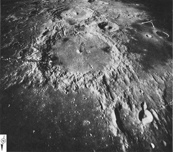
FIGURE 25 [above] .-This south-looking oblique view shows three of the best-known features of the near-side central highlands: the alined craters Ptolemaeus (P), partly in view in the foreground; Alphonsus (A), in the center, and Arzachel (Arz) beyond. The latter is 100 km in diameter. Alpetragius (Alp), with its peculiarly large central peak, is not alined with the others. The three large craters are filled-Ptolemaeus most deeply-by deposits of light plains material. This type of material fills depressions over most of the lunar terrae but is concentrated in this part of the central highlands and in two or three other belts on the near side. In Alphonsus the plains deposits are overlain by dark material in halos surrounding elongated craters. Most of these dark halo craters are situated along rilles and are the sites of reported temporary changes in telescopic appearance. The dark halo craters on the eastern (left) side were the target of the Ranger 9 spacecraft, the last of three successful Ranger missions that impacted the Moon more than 7 years before this photograph was taken.
Some lunar geologists believe that the alinement of the three big craters is controlled by a fundamental structure within the Moon's crust. However, because the three craters are quite different in age, the alinement is more probably coincidental. When Arzachel formed, debris was ejected to form a radial chain of secondary craters on top of the light plains deposits that fill the other two craters. This shows that Arzachel is the youngest of the three craters. Ptolemaeus, considerably more degraded than the other two, is also covered by ejecta from Alphonsus and is the oldest of the three. An extensive additional geologic history can be read from the photograph by extending this type of reasoning. The rims of Ptolemaeus and Alphonsus are cut by a conspicuous system of parallel ridges and grooves called "Imbrium sculpture" because it radiates from the Imbrium basin, behind (north of) the camera. Part of this sculpture is in turn intersected by the Davy crater chain (D) in the lower right of the picture. Further, the highland materials are overlain by the obviously younger mare materials in the upper right of the picture. Fresh craters (for example, C) and their bright halos overlie the maria. Therefore, from oldest to youngest, the complete historical sequence is Ptolemaeus, Alphonsus, Imbrium sculpture, light plains deposits, Arzachel, Davy chain, mare materials, and rayed craters. The dark halo craters in Alphonsus are as young or younger than the mare materials. Application of similar geologic reasoning based on overlapping and crosscutting relations has unraveled, in terms of relative age, the evolution of most of the lunar surface.-D.E.W.
|
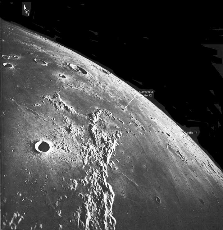
[39] FIGURE 26 [below] .- Apollo 16 crossed the central highlands and then looked northward into southern Oceanus Procellarum. This region contains a mixture of terrae and of younger mare material that has flooded the terrae. The large terra mass in the foreground is Montes Riphaeus, which consist of the unflooded remnants of the rim of a large basin and the rims of two or three inundated craters. Islandlike continuations of the basin rim can be seen arcing eastward (right) from the north end of the mountains. The mare that occupies this basin in the lower right of the picture is called Mare Cognitum, the "Sea That Became Known" - but not until visited by the first successful U.S. lunar mission, Ranger 7, in July 1964. Two years and 9 months later, Surveyor 3 landed on the mare north of Montes Riphaeus along a ray of bright material emanating from the crater Copernicus. Surveyor was joined in November 1969 by Apollo 12. Then, in January 1971, after an earlier aborted try by Apollo 13, Apollo 14 landed on the terra bordering the east side of Mare Cognitum (near the horizon in this picture). The materials at the Apollo 14 landing site had been mapped as the Fra Mauro Formation and interpreted as ejecta from the Imbrium basin long before the landing. Although the site is nearly 1200 km south of the center of the Imbrium basin, the results of the mission substantiate this interpretation and verify the magnitude of the event that formed the basin. Islands and peninsulas of terra in the upper left part of the picture are also probably structures and deposits formed by the Imbrium impact.- D.E.W.
|
 |
|
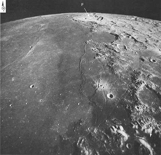
[40] FIGURE 27 [right] .-On the near side, Apollos 15 and 17 flew over a more northerly strip of the Moon's surface than did Apollo 16 (fig. 1). Here, over the eastern edge of Mare Serenitatis, another mare that fills a circular basin, the Apollo 17 mapping camera recorded the regional setting of the Apollo 17 Taurus-Littrow landing site (arrow, lower right corner). The relatively smooth and unusually dark material around the edge of the basin contrasts sharply with the hummocky bright mountain massifs of the basin rim. Trending along the edge of the basin, an exceptionally fresh system of scarps, mare ridges, and rilles transects both mare and terra. The rilles, mostly straight or gently arcuate, are fault valleys called "grabens." Near the distant horizon is the flat-floored, partly flooded crater Posidonius (P), about 100 km in diameter. Just this side of it is a bay formed by the flooding of the older crater Le Monnier, which was visited by the unmanned Soviet roving vehicle Lunokhod 2 in January 1974. Days earlier the Apollo 17 mission had been successfully concluded. During a 3-day stay on the Moon at the Taurus-Littrow site (arrow), the dark material on the valley floor, the avalanche of light- colored debris (A), and the mountains surrounding the site were visited and sampled by the astronauts.-D.E.W.
|
 |
|
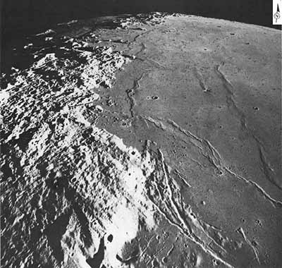
[41] FIGURE 28 [right] .-A comparable view of the opposite (west) side of Mare Serenitatis taken only a few minutes after figure 27 during the same revolution. Now closer to the terminator, the smaller angle between the Sun's rays and the lunar surface causes an enhancement of topographic relief. Mare ridges appear to be higher and rilles or grabens deeper than on the east side. In both areas the ridges and rilles are grossly parallel to the edge of the mare. Rimae Sulpicius Gallus, the prominent rilles in the lower part of the picture, and the dark plateau into which they are cut are embayed by the younger mare plains. Some of the mare ridges, especially the sharper crested ones, may be younger than the bulk of the mare plains. All of these features are younger than the rugged Apennine Mountains (left) and the Caucasus Mountains (center of the horizon). The two mountain ranges form part of the rim of both the Serenitatis basin and the Imbrium basin (to the left of the ranges).-D.E.W.
|
 |
|
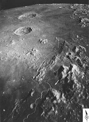
[42] FIGURE 29 [right] .-The Apollo 15 landing site, marked by an arrow, is visible in this north- looking oblique photograph. This is one of the northernmost views photographed during the Apollo missions. The Caucasus Mountains are on the upper right horizon, with Mare Serenitatis off the image on their right and Mare Imbrium on their left. Two large rayed craters, Aristillus (Ar) and Autolycus (Au), 55 and 40 km in diameter, respectively, penetrate the mare. In September 1959, the first manmade object to strike the Moon, the Soviet Luna 2 spacecraft, impacted just west of Autolycus. The massive mountains in the foreground are the Apennines. At their western slope is the sinuous Hadley Rille, which was examined at close range by the Apollo 15 astronauts who drove to its eastern rim in the first manned roving vehicle used on the Moon.-D.E.W.
|
 |
|
| |
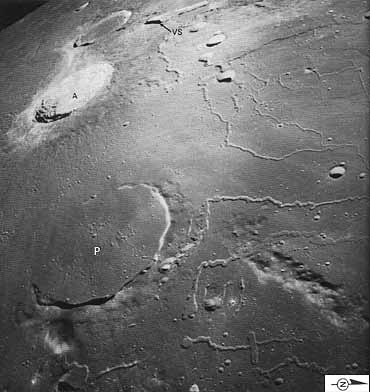 |
FIGURE 30 [left] .-West of the Apennines (by 1300 km) on the opposite side of Mare Imbrium is the peculiar complex of Montes Harbinger (bottom right) and the Aristarchus plateau (top). These uplifted features probably represent the outermost rim structures of the Imbrium basin. They protrude through a mare that is infested with sinuous rilles and some straight rilles. Features of the rich scene include the head of Vallis Schroteri (VS), or Schröter's Valley; the old mare- flooded crater Prinz (P); and one of the Moon's youngest and brightest large impact craters, Aristarchus (A). Aristarchus, which is 43 km in diameter, has been the site of frequent "transient lunar phenomena" (temporary changes in color or brightness) reported by many telescopic observers throughout the world.-D.E.W.
|
 |
[43] Figure 31 [left] .- During the various Apollo missions, the west limb of the Moon was in shadow behind the terminator and could not be photographed. This south-looking oblique view across western Oceanus Procellarum shows one of the western-most areas visible to the astronauts. As the word "oceanus" (=ocean) implies, Procellarum is larger than a mare. Like the maria however, it is formed by dark mare materials that originated as flows of basaltic lava. The crater Seleucus, 42 km in diameter, is shown in sunrise along the right (west) edge of the frame. The narrowness of its rim and the abrupt contact between its raised rim and the surrounding mare prove that the final mare flooding occurred after the crater was formed. In other words, the crater predates at least the youngest mare basalts in this area. The same age relations hold true at Schiaparelli, the second largest crater in view. Several medium-sized craters and countless small craters are surrounded by finely textured outer ejecta deposits and hence are younger than the mare. The Marius Hills, the most extensive aggregation of volcanic domes and cones on the Moon, are visible on the left horizon. Thus the picture shows the characteristic events of late lunar history-the sporadic formation of impact craters concurrent with volcanic eruptions that form lava plains, hills, and ridges. D.E.W.
|
| Next |