
Chapter 3: The Terrae (2/2)
 | |
|
[55] AS15-90-12187 (H) |
AS15-90-12209 (H) |
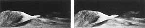
FIGURE 43 [above] .-This stereogram showing part of the Apennine Mountain chain is composed of two Hasselblad frames taken from the Moon's surface. To facilitate the postmission geologic study of the landing site, the astronauts took a panoramic series (a clockwise sequence) of horizontal photographs at each major sample collecting station. Both these photographs look northeast from stations about 250 m apart along one of the EVA traverses at the Apollo 15 site. The foregrounds, which do not cover a common area, have been eliminated from the stereogram. The impression of depth in the background is greatly enhanced in comparison with the direct view of the astronauts. The mountain at the left is Mount Hadley at a distance of 20 km. The faint lineations trending downward to the left on Mount Hadley's face are the features that were believed by some investigators, at the time of the mission, to be steeply dipping strata; however, the explanation given in figure 42 now seems more likely.-L.J.K.
|
[56] |
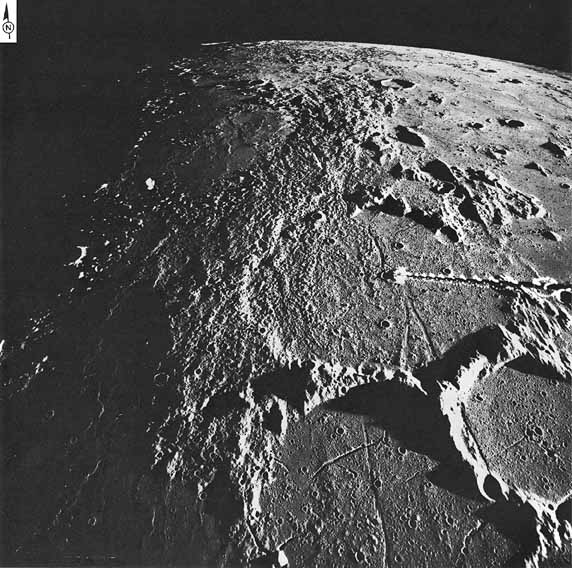 |
FIGURE 44 [above] .-A north looking oblique view of the region surrounding the Apollo 14 landing site (arrow), about 600 km south of the Imbrium basin, which is just beyond the horizon. The fine, hummocky material extending through the center of the frame from the lower edge to the horizon has been mapped as ejecta from the Imbrium basin and designated the Fra Mauro Formation. The formation is most easily distinguished in the western half of Fra Mauro, the large (95 km) crater near the center. In the eastern half of the same crater the formation is either absent or is too thin to be visible. The straight rilles trending toward the lower right corner of the frame may be related to the radial stresses generated by the Imbrium event, but detailed mapping has shown that they are much younger in age.-M.W.
|
[57] |
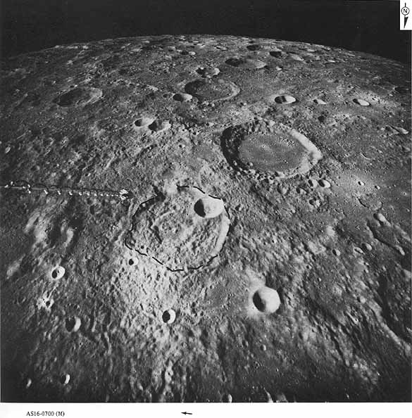 |
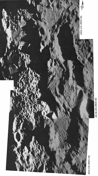
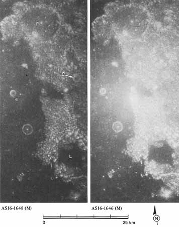
FIGURE 45 [above] .- These terrae of the central highlands are near the Apollo 16 landing site. The landing point is indicated by the arrow just below the lower (northern) edge of the picture. Here the terrae are less rugged and less densely cratered than those on the far side, shown in figure 33. The subdued appearance of these near side terrae is attributed to accumulations of successive blankets of ejecta from impact basins and possibly to the accumulation of volcanic materials in this, the topographically highest region on the Moon's near side. Descartes, for which the landing site was named, is the ancient, highly subdued crater near the center. It is 47 km in diameter and so indistinct in this view that its rim has been outlined by dashes. The unusual Abulfeda crater chain extends for a distance of 225 km across the upper part of the picture.-G.G.S.
 | |
|
AS16-0976 (M) |
AS16-0974 (M) |
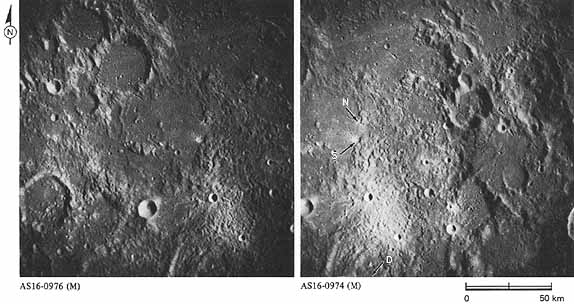
[58] FIGURE 46 [above] .-In contrast to figure 45, which is an oblique view looking southward, this is a vertical view arranged for stereoscopic viewing. North is at the top and the crater Descartes (D) is partly visible at the lower edge. The craters North Ray (N) and South Ray (S) are prominent landmarks used during the planning and conduct of the mission. The LM landed between the two. The age of South Ray is discussed in more detail in figure 105. The smooth materials filling most topographically low areas are mapped as the Cayley Formation. Samples of the Cayley excavated from the craters were collected by the astronauts. Most of the samples consisted of feldspar rich breccia. This is consistent with an early interpretation (Eggleton and Marshall, 1962) that the Cayley accumulated as ejecta from large multiringed basins, probably Imbrium (1400 km to the northwest) and Orientale (2800 km to the west). The more rugged material immediately east of the landing site is designated as the Descartes Formation. Originally interpreted as volcanic deposits, it is now thought to consist mostly of breccia, although the samples collected may not be representative of the entire formation. From the evidence presently available, its origin as basin ejecta, possibly from the Nectaris basin 450 km to the east, seems to be the most likely explanation.-G.G.S.
FIGURE 47 [below] .-The ruggedness of the grooved and furrowed terrain of the central lunar highlands is emphasized here under low Sun illumination of about 3° compared with an illumination angle of about 27° in figure 46. In the north south direction, this mosaic covers a distance of 210 km. While these photographs were taken, the Apollo 16 crew was completing its first revolution in orbit and described the scene as follows: "In this lighting, you can see the crater Descartes, and it stands out much bigger than you would expect because of the low Sun angle. In fact, I had to look up my map to make sure that that was what I was looking at. . . . It looks very much like a big clinkery cinder field, . . . a big, rounded surface of clinkers. It is fantastic . . . boy, is that rough!" The crater Descartes itself (D) is subdued and partly covered by the rough topography. The Apollo 16 landing site (arrow) is in a gap within the grooved and furrowed unit. Contrary to premission beliefs that this unit was of volcanic origin, returned samples from the site are breccias formed by shock metamorphism of the highland rock. F.E. B.
|
[59]
|
 |
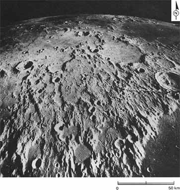 |
[60] FIGURE 48 [left] .-A basin forming event severely affects the terrain even beyond the outer margins of its ejecta deposits. This system of ridges and grooves known as Imbrium sculpture is radial to the Imbrium basin, located beyond the upper left horizon about 650 km from the center of this scene. The crater Herschel, 40 km in diameter, is at the center of the right edge. It is perched on the grooved rim of Ptolemaeus, part of whose floor and rim is visible in the lower right corner. Both secondary impact and faulting have been proposed as causes of the ridges and grooves, but in any case the sculpture must have been produced by the same event that produced the Imbrium basin.-D.E.W.
|
|
| |
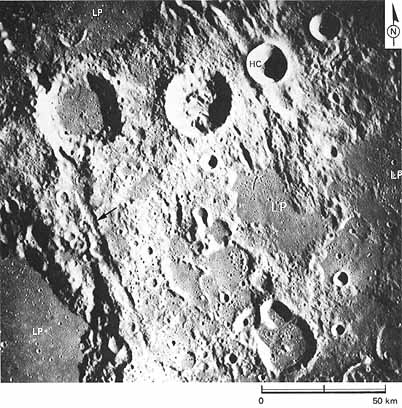 |
FIGURE 49 [left] .-An area centered about 900 km southeast of the Imbrium basin, illustrating again the radial fracturing and sculpturing of terra materials by the basin forming event. The arrow points to a 120 km long fracture that cuts the rims of the partly visible crater Albategnius in the lower left of the photograph and the crater Halley toward the upper left. It and similar trending fractures elsewhere in this picture are radial to the Imbrium basin and are related to its formation. The crater Hipparchus C (HC) is superposed on a fracture and, therefore, is younger than the Imbrium basin and the Imbrium sculpture. Light plains forming materials (LP) are younger than the Imbrium event, as indicated by the absence of fractures and the scarcity of superposed craters. Light plains deposits are a major stratigraphic unit of the terra regions and will be illustrated in more detail beginning with figure 53.-M.W. |
|
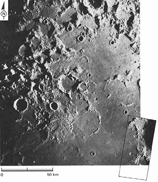
[60] FIGURE 50 [right] .-Between Mare Crisium and Mare Serenitatis Apollo 17 approached its eventual landing site, which is in shadow at the left edge of the photograph (white arrow). The area consists of both mare and terrae. Maraldi, a crater described in figure 52, is shown by the black arrow. A markedly rectilinear pattern of major terra features and mare terra contacts is characteristic of this area. Closely spaced intersecting structures also produce a finely textured pattern of equidimensional hills. The northeast and northwest directions of the large and small structural elements are less consistent with structural trends of the nearby Crisium and Serenitatis basins than with the more distant Imbrium basin. Therefore, Imbrium ejecta or seismic energy may have produced the structures. When viewed under conditions of high angle lighting, the pattern of small hills is referred to as "corn on the cob" or as "sculptured hills." The appropriateness of these terms is demonstrated on the next figure, a stereogram enlargement of the rectangular area in the lower right corner of this picture.-D.E.W.
|
 |
|
| |
|
FIGURE 51 [right] .-The southeastern corner of figure 50 is shown here as a stereogram of two Apollo 16 pictures taken when the Sun angle was much higher. The contrasting albedo (brightness) of the dark mare and bright terra is enhanced under these lighting conditions. When viewed stereoscopically, the "corn on the cob" texture of the terra is readily apparent. The rims and walls of the ancient craters Franz (F) and Lyell (L) have been severely degraded by erosion and show the same texture as the adjacent terra. These two craters contrast strongly with the much younger crater (C) whose original form has not been significantly degraded. D.H.S. |
 |
|
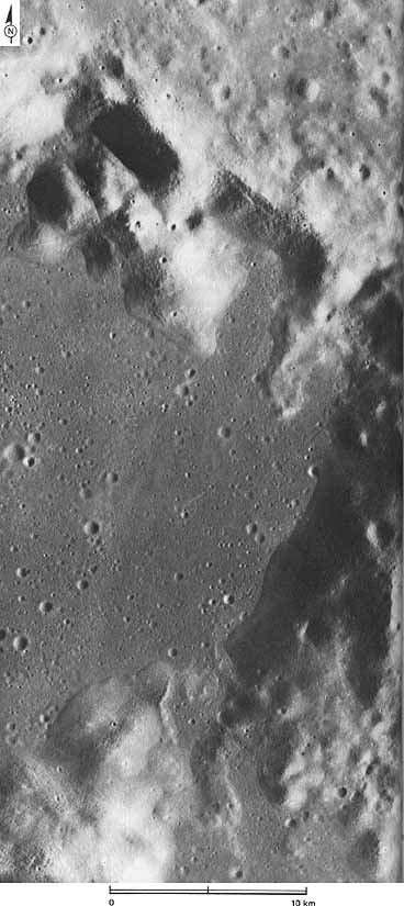
[62] FIGURE 52 [right] .- Maraldi, a 45 km impact crater, was shown in its regional context in figure 50. Its rectilinear shape is in striking contrast to the circular or oval shape of most lunar impact craters. Faulting along northwest and northeast planes, probably generated by the Imbrium event, is the cause of the unusual configuration of its walls. Debris aprons form a narrow but continuous terrace along the base of the crater wall. The high rate of mass wasting on the steepest slopes is proven by the low density of craters superposed on the crater walls in contrast to that of the much younger mare surface in the floor of Maraldi. Ultimately, as depicted near the north edge of the picture, landforms evolve toward rounded forms partly buried under their own debris aprons.-M.J.G.
|
 |
[63] FIGURE 53 [above] .-Light plains are a conspicuous feature of several lunar terra regions including the central near side highlands. In this scene essentially all flat lying areas are covered by plains deposits. No mare materials are visible. Light plains deposits are not completely planar but faintly reveal underlying relief. The subdued features that underlie the plains deposits in the floor of the large crater Albategnius (lower center) are craters and linear "Imbrium sculpture" troughs like those on the rim of Albategnius and in the adjacent highlands. The rim crest diameter of Albategnius is about 130 km.-D.E.W.
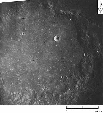
[64] FIGURE 54 [above] .-This picture shows the subdued, 1 50 km diameter, crater Ptolemaeus. The crater is filled to about half its original depth by the Cayley Formation, a unit with a gently undulating, nearly smooth surface. This unit forms similar smaller pools in numerous irregular depressions at various levels on the rim, flank, and wall of Ptolemaeus. The Cayley Formation consists of patches of light colored plains materials that fill most depressions peripheral to the Fra Mauro Formation (fig. 44) in the central earthside lunar uplands. Undulating surface features on the Cayley include very subtle circular depressions (d) 10 to 15 km in diameter that are more than an order of magnitude larger than the craters superposed on the Cayley, and irregular swells, swales, and scarps. Other surficial features are small, equidimensional, steep sided hills (h). The latter may have been formed on the surface of the Cayley by eruption of material from within the unit. In addition, more than 30 small craters on the Cayley have small central mounds (fig. 55). These mounds may represent relatively strong material that underlies a weak surficial layer of post Cayley regolith, indicating that the regolith is thicker here than on mare surfaces.
The deposition of the Cayley in pools indicates that it moved partly as a fluid. The distribution of the pools peripherally to a deposit of basin ejecta, the Fra Mauro Formation, indicates a related origin. The large, subdued crater forms suggest that the Cayley material is a draped blanket of fragmental material. Therefore, my colleague G. G. Schaber and I have suggested that the Cayley is a deposit of basin ejecta that became segregated from the ballistically transported ejecta that formed the Fra Mauro Formation around the Imbrium basin. The Cayley was transported separately as a fluidlike cloud that flowed along the ground across the whole region; portions were left behind to accumulate in local depressions . R. E.E.
 |
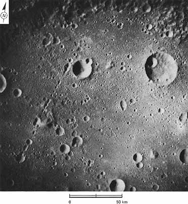
[65] FIGURE 55 [left] .- This picture shows Ptolemaeus under a Sun elevation angle of 45°. The undulations on the Cayley Formation are so subtle that they disappear under the high Sun. The arrows point to examples of the small, relatively sharp, young craters with central mounds mentioned in figure 54. The mounds may be harder than the shallower materials and may indicate the depth of the regolith formed on the Cayley.-R.E.E.
|
|
| |
|
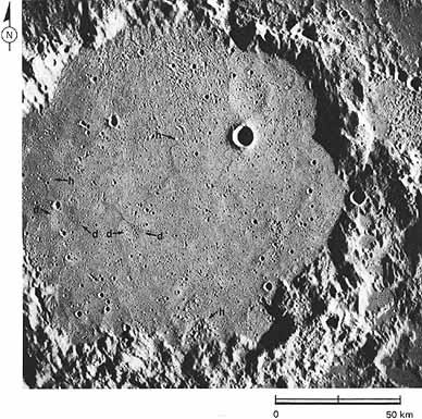
FIGURE 56 [right] .-The very large crater or small multiringed basin Mendeleev is shown here at the same scale as the preceding two pictures of Ptolemaeus. Like Ptolemaeus, Mendeleev is largely filled by plains material. In this case, however, subsequent cratering has been much more extensive, indicating that the Mendeleev plains are older than those in Ptolemaeus. The source of these plains materials on the far side of the Moon is unknown. The linear chain of elongate craters near the left side is probably of secondary origin, formed by the impact of fragments ejected from Tsiolkovsky (850 km to the southwest). -D.E.W. and C.A.H.
|
 |
| Next |