
Chapter 6: Rimae (2/3)
Sinuous Rimae (continued)
|
[188] |
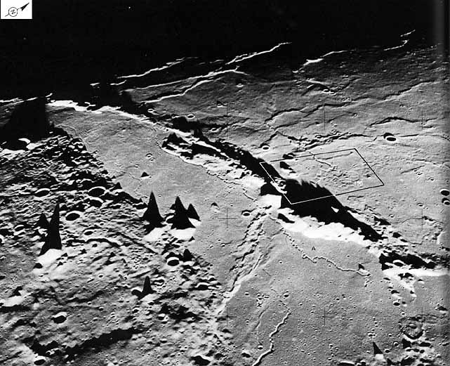 |
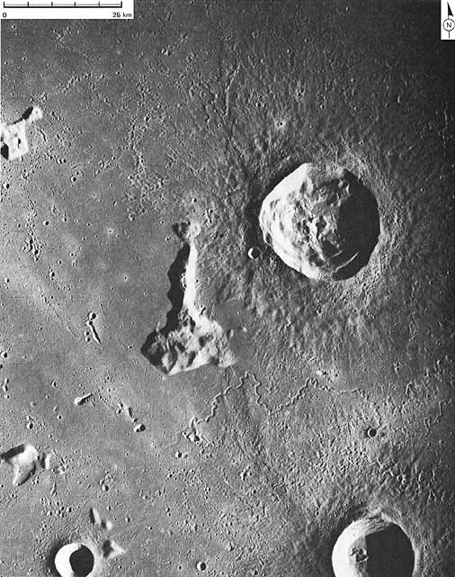
FIGURE 195 [above].-Relief is exaggerated in this near terminator (low Sun) photograph of the northwest margin of the Aristarchus Plateau. A broad graben (approximately 15 km wide) separates the rugged linear mountain chain from the sloping plateau surface. The crenulate profiles of mare wrinkle ridges (some as high as 200 m) are visible on the horizon; one mare ridge bisects the graben. Sinuous rilles are prominent in the graben; several originate on the plateau. The surface of the mare in the graben appears to be higher on the west side of the mare ridge, suggesting faulting associated with ridge formation. The rille A crossing the ridge is nearly 100 km long and has interlocking meanders, which preclude its formation as merely a crack in the mare surface; erosion by downstream transport of a fluid seems necessary to explain such sinuosity. Origin of the diamond shaped Aristarchus plateau itself is enigmatic, although its relatively straight edges suggest fault control.-C.A.H.
|
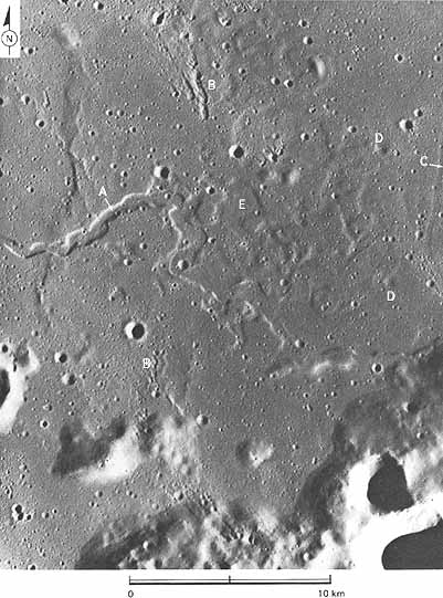
[189] FIGURE 196 [right].-Sinuous rille (A) is unusually shallow for its width and has probably been mantled or filled since its formation. The entire area shows evidence of an older mantled and subdued topography on which secondary craters (B) from the 40 km primary crater Aristarchus (to the southeast) have been superposed. Among the mantled features are a straight rille (C), craters (D), and numerous polygonal depressions (E), which may be subsidence features, possibly caused by withdrawal of magma at depth, or differential compaction of lava over small highland blocks. The Aristarchus plateau is to the southeast. C.A.H.
|
 |
|
| |
|
FIGURE 197 [right].-A number of mare related features are present in this oblique view looking north across a mare surface between Mare Imbrium and Oceanus Procellarum. A broad mare arch is visible in the foreground. As it is followed toward the northwest the arch gives way to a series of small ridges, which then converge on an unusual sinuous chain of craters, elongate ridges, and elongate depressions. This sinuous chain leads into a large arcuate elongate depression at the boundary between the highlands and the mare. Similarity of parts of this structure to parts of some sinuous rilles, for example, Rima Hadley, suggests that its strange morphology may be a poorly understood variation of a lava channel, possibly a partially collapsed lava tube.-J.W.H. |
 |
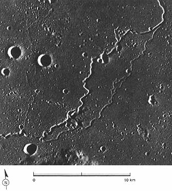 |
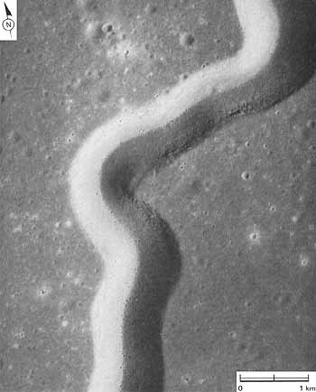
[190] FIGURE 198 [left].-The branching sinuous rille in this photograph is part of a continuous single rille extending more than 300 km across the mare in northeast Oceanus Procellarum. The width of the rille is essentially constant (approximately 250 m) throughout its length. The secondary branches, all of which rejoin the main "stream," are shallower than the larger channel. Slope is probably northeast toward the center of Mare Imbrium. Like some other lunar rilles, this one crosses several mare ridges with no apparent deviation or deformation; unlike many rilles, particularly those near the Aristarchus plateau, there is no associated crater at either end. The origin of lunar sinuous rilles remains controversial. Among the alternatives proposed are lava channels and lava tubes, but fracture control is decidedly apparent in some places. Some sort of fluid erosion, however, seems necessary to account for the configurations of many rilles with exactly parallel walls from which material has been removed; lava may be the most plausible agent for erosion inasmuch as no evidence of water exists in the lunar samples. The diversity among rilles suggests that several genetic hypotheses may be required to explain all of them.-C.A.H. |
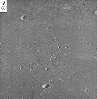
FIGURE 199 [below].-Delisle and Diophantus are two relatively young craters, 27 km and 19 km in diameter, located north of the area shown in figure 198, in the western reaches of Mare Imbrium. Both are younger than the mare materials in which they are excavated, and also younger than the narrow sinuous rille between them. The rille is sculptured by lineaments radial to the rim crests of Diophantus or Delisle; the lineaments presumably were produced by ejecta from one or both craters.
Both craters exhibit characteristics of young lunar impact craters that have undergone relatively little degradation. The rim crest is sharp, slump terraces inside the walls are distinct, and the density of younger superposed craters is low: only one very young rayed crater, 3 km in diameter, is superposed on Diophantus ejecta.
Five major morphologic facies of crater ejecta can be distinguished in concentric zones away from the crater rim crests: (1) closest to the rim crest, a zone of pitted terrain, dotted with tiny circular craters and large blocks; (2) a zone of rolling troughs and ridges with a smooth surface, grading outward into the third type; (3) elongate or chevronlike secondary impact craters, the rim crests of which form ridges radial to the rim crest of the primary crater; (4) a reticulate network of discontinuous ejecta, forming ridges radial to the rim crest of the primary crater; and (5) isolated secondary impact craters that dot the surface of preexisting mare materials.
The scarp bounded mountains west and southwest of Delisle are massifs of light toned circumbasin materials that are older than the mare and crater materials around them.-M.J.G.
|
[191] |
|
|
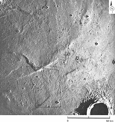
[192] FIGURE 200 [right].-Low Sun angle photograph of mare surface taken by the metric camera. Two large impact craters, Diophantus and Euler, occur in the upper left and lower right comers of the frame; the terminator lies at the left margin of the picture. Many secondary crater chains and smaller primary craters pepper the mare surface, and lava flow fronts, mare ridges, and rilles are common. The rilles exhibit a marked branching or dendritic network pattern. The lava channels become narrower and shallower downstream, to the northeast; terrestrial lava channels also commonly become shallower downstream. The lobes of the lava flows also point northeastward. Apparently the material filling the basin moved from southwest to northeast in this region. The lava flows and rilles obviously antedate the impact craters that pockmark the surface. The outlined area shows the location of figure 201.-H.M.
|
|
|
| |
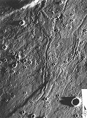 |
FIGURE 201 [left].-This low Sun angle, high resolution picture shows in greater detail the branching network of lava channels displayed in figure 200. The long shadows along the channel network are formed by its natural levees of chilled lava. The channels branch downslope, as is customary in lava distributary systems on Earth. Small impact craters that postdate the lava flows riddle the channel margins and bottoms and saturate the lava surfaces. Many form lines of secondary craters. Tectonic displacements (faults) offset the lava surfaces and cut across the lava channels; they are, therefore, considered to be younger than the lava channels.-H.M.
|
|
[193] |
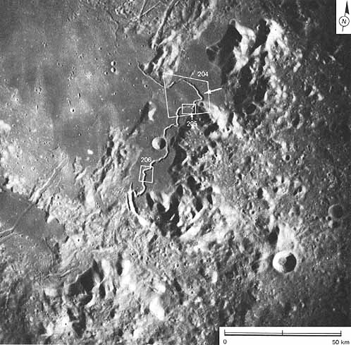 |
FIGURE 202 [above].-This Apollo IS photograph depicts the sinuous Hadley Rille, the Apennine Mountains trending from lower left to upper right, and the smooth surface of Palus Putredinus (Marsh of Decay) in the upper left quarter. The Apollo 15 landing site at 26.4° N, 3.7° E (arrow) was selected because of the variety of important lunar surface features concentrated in the small area. The Apennine Mountains, with almost 5 km of relief in the area pictured, are a part of a ring of mountains that surrounds the Imbrium basin and in which very old rocks are thought to be exposed. The smooth lava flows of Palus Putredinus formed later, and Hadley Rille, sharply etched in the mare surface, is thought to be one of the youngest rilles on the Moon. The V shaped rille originates in a cleft at the base of the mountains in the south and gradually becomes shallower and less distinct to the north and west. Layered rocks crop out in its walls at several places. Near the landing site, the width of the rille is 1.5 km and its depth is more than 300 m. M.C.M.
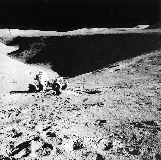
[194] FIGURE 203 [below].-Astronaut James Irwin and the Apollo 15 rover are perched here above the rim of Hadley Rille. This scene looks northwestward down the rille from the flank of St. George crater (the largest crater in fig. 204). The astronauts discovered that layered basalts crop out in the upper walls of the rille. Talus blocks line most of the walls and the floor of the rille. The rille apparently was once narrower and deeper but has widened by backwasting of the rims. K.A.H.
|
[195] |
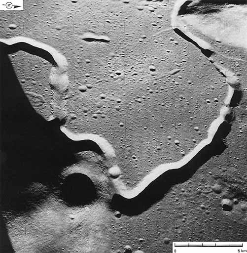 |
FIGURE 204 [above].-Here is how Hadley Rille first appeared to the Apollo 15 astronauts in the LM. They landed in the right foreground. The large subdued crater in the foreground, St. George, is on a mountain to which astronauts drove. Hadley Rille is mainly in the mare basalts of Palus Putredinus. The rille cuts against older mountains in the foreground and at the upper right. Along the top (north) of this photo the rille is discontinuous and is similar in many respects to a partly collapsed lava tube, although it is much bigger than any terrestrial counterpart. The rille is 1.5 km wide and over 300 m deep. It is thought to be a giant conduit that carried lava from an eruptive vent far south of this scene. Topographic information obtained from the Apollo 15 photographs supports this possibility; however, many puzzles about the rille remain.-K.A.H.
|
[196] |
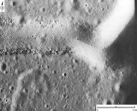 |
FIGURE 205 [above].- This closeup of Hadley Rille was taken by the Apollo 15 panoramic camera. This part of the rille appears along the left side (south) of figure 204 under different lighting conditions. Rocky outcrops along the top of the rille walls appear to be cut by fractures, called joints. The blocks that have rolled to the bottom of the rille are huge, up to tens of meters across. K.A.H.
|
|
[197] FIGURE 206 [left].-This part of Hadley Rille is far south of the landing site. Lines of outcrops of mare basalt in the upper rille walls suggest thick layering in the basalt. Notice how the edges of the rille stay parallel to each other. One origin suggested for the rille is that it is a graben or fault valley. In its present form, however, the rille could not have formed as a fracture because the sides will not fit back together.-K.A.H.
|
|
| |
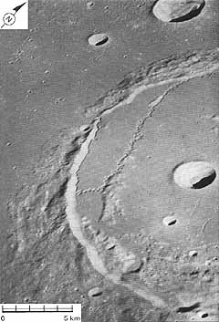 |
FIGURE 207 [left].-The large (approximately 100 km) crater Posidonius is filled with mare lava to a level higher than the surrounding surface of Mare Serenitatis. The most interesting and perplexing feature of this crater is Rima Posidonius II-the highly sinuous rille that follows a devious course from the north rim of the crater at upper right (outside the photograph) through the breach in the crater rim at center. The rille is topographically controlled in part, hugging the juncture between lava and crater material. Erosion by some sort of fluid may have formed the rille; material appears to have been removed from it. An alternative explanation might be that the feature represents a drained and collapsed lava tube. The fluid involved probably was emitted from the craterlike depression at the head of the rille in the crater's north wall. If the rille is assumed to be contemporaneous with the lava filling, a lava of low viscosity would seem to be required to explain the channel's high sinuosity. C.A.H.
|
| Next |